


The mapping applications on our smartphones and in our cars rely on signals from a constellation of navigation satellites to pinpoint our location. When these signals are reflected back into space, they are imprinted with data about the Earth’s surface features and conditions.
The distortions and delays of the reflected signal paths can be used to gain valuable insights about the Earth’s surface, meaning that the constellation could be used to monitor such things as moving objects, the heights of surface features, wind speed/direction, humidity, and other many other kinds of surface-related data.
This opens up the possibility to use that data in a growing number of diverse applications, such as weather forecasting, scientific research, transportation, innovative commercial applications, agriculture and others, which will provide added value to these constellations in the near-term.
However, currently there isn’t a universal way to do that because the many different satellite navigation constellations in use around the world use a mix of data processing techniques, instruments and retrieval algorithms to perform their missions. The heterogeneous nature of these signals, as well as diverse working methodologies, require a global standard to bring about a viable, operational Earth observation technique.
The IEEE Standards Association (IEEE SA) recently published a new standard, IEEE 4003™ – 2021, IEEE Standard for Spaceborne Global Navigation Satellite System-Reflectometry (GNSS-R) Data and Metadata Content, which provides a uniform way to configure and manage data and metadata content from these reflected signals.
IEEE 4003 is Applicable to Diverse Satellite Systems
In the United States most people call the relevant navigation satellite constellation the Global Positioning System (GPS), but generically it is referred to as a Global Navigation Satellite System (GNSS), and it is one of four GNSS systems which collectively cover the Earth:
- The U.S. GPS has 31 medium Earth-orbit (MEO) operational satellites.
- The Russian GLObal’naya NAvigatsionnaya Sputnikovaya Sistema (GLONASS) has 24 MEO operational satellites.
- The European Galileo GNSS has 24 MEO operational satellites.
- The Chinese BeiDou-3 has 3 Inclined GeoSynchronous Orbit (IGSO), 24 MEO, and 2 geosynchronous equatorial-orbit (GEO) operational satellites.
In addition, there are several regional navigation constellations which further increase the number and diversity of signals available for remote-sensing purposes: the Japanese Quasi-Zenith Satellite System (QZSS) with 1 GSO and 3 Tundra-type orbit operational satellites, and the Indian Regional Navigation Satellite System (IRNSS) with 3 GEO and 4 IGSO operational satellites.
Receivers with GNSS-Reflectometry (GNSS-R) sensors are used to pick up the reflected signals. GNSS-R can be thought of as a passive multi-bistatic radar (i.e., one where the transmitter and receiver are not co-located) in the L frequency band. In principle, spaceborne GNSS-R sensors can provide global coverage and sampling of the Earth’s surface over multiple tracks simultaneously.
IEEE 4003 Addresses the Needs of the New Space Era
In 2017, the IEEE Geoscience and Remote Sensing Society (GRSS) created the GRSS Standards for Earth Observation Technical Committee to advance the usability of remote sensing products by experts from academia, industry, and government through the creation and promotion of standards and best practices.
Subsequently, the IEEE Working Group on Spaceborne GNSS-R was formed to address the needs of what is being called the New Space Era, which is based on the idea that existing satellites can be used to develop and deploy new products and services to help business, governments and society at large achieve their goals in ways that are not otherwise possible or cost-effective.
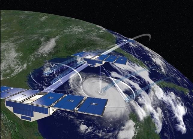
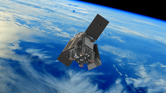
In particular, the scope of the Working Group was to develop a standard for data and metadata content arising from past, present, and anticipated future spaceborne missions. Examples include the U.S. National Aeronautics and Space Administration’s (NASA’s) CYclone Global Navigation Satellite System CYGNSS constellation (Fig. 1), coordinated by the University of Michigan; and the European Space Agency’s (ESA’s) Hydrology using Global Navigation Satellite System reflections HydroGNSS mission (Fig. 2).
Trends in GNSS-R, such as multi-plane constellations of small satellites, combined with future advancements in satellite subsystems and retrieval algorithms, will help to further the performance of GNSS-R so as to derive geophysical parameters of interest, such as wind speed, ocean surface height, soil moisture content, biomass, inland water, and sea ice.
As such, the IEEE 4003 standard is focused on the definition of the main parameters required for the generation of scientifically valuable products. It aims to provide a strong foundation for GNSS-R data in order to further explore and advance the limits of this technique, independent of the constraints imposed by current geophysical parameters retrieval algorithms.
Learn More
We invite GNSS-R mission teams from throughout the world to learn more about the new IEEE 4003 Standard for Spaceborne GNSS-R.
Author: Hugo Carreno-Luengo, Chair, IEEE Working Group on Spaceborne GNSS-R